

Collection: Smith Collection
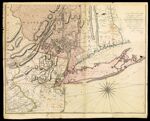
Name: A Map of the Province of New York with part of Pensilvania, and New England, from an actual survey by Captain Montresor, engineer, 1775. P. Andrews, sculp.
Barcode:
Image Number:
Creator:
Date/Date Range Produced:
Date/Date Range Published:
Language:
Dimensions: 144 x 93 cm. on 2 sheets 75 x 96 cm. and 76 x 98 cm
Notes: Dedication: "To the Right Honourable Sir Jeffery Amherst Knight of the Bath, and Lieutenant General of his Majesty's Forces &c. &c. &c. This Map of the Province of New York, is humbly inscribed by his most obliged Humble Servant, John Montresor Engineer." Sectioned and mounted on cloth backing. Shows administrative divisions. Includes continuations of Lake Champlain and the Connecticut River
Physical Description: 1 map: hand colored
LC Call Number: G3800 1775 .M6
OCLC: 5401125
Accession Number: SM-1775-20.2
Donor:
Permanent URL: