

Collection: Osher Collection
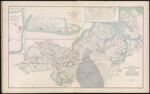
Name: Military map of Suffolk and vicinity for Brig. Gen. E. L. Viele
Barcode:
Image Number:
Creator:
Date Created:
Date Published:
Alternative Title: Plan of Fort Esperanza, Tex.; Map of Morris Island and the adjacent creeks from U.S. Coast Survey 1823-4 Sand hills from a survey 6th June, 1862.; Proposed secondary line of defense on the peninsula between Ashepoo and Combahee Rivers, S.C. November 4, 1863.
Notes: "December 11th" "November 27th" "June 6th" 1863 - Inscribed on Map; Between 1823 and 1824; 1862 - Inscribed on Map
Permanent URL: