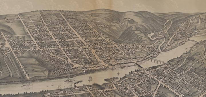
Albert Ruger, Bird’s Eye View of the City of Augusta Maine. 1878 (Madison, Wis.: J. J. Stoner, 1878).
The development of lithography in the nineteenth-century created an opportunity for the development of major new markets for maps in the USA, and especially of counties and urban places. Lithography permitted many different maps to be reproduced easily and cheaply, albeit each in only a relatively small number. Enterprising entrepreneurs could marshal teams of surveyors, engineers, and artists to target rapidly growing towns and counties across the country, where they could raise the money necessary to make a map by appealing to civic pride and business interests and pre-sell copies through a subscription system. Once enough subscribers had been attracted to cover the cost of production, draftsmen, surveyors, and engineers produced the base map and artists created the illustrations and decorative borders. The results were town and county maps such as the 1856 Map of Kennebec Co.
After the Civil War, a new genre was marketed through subscription schemes to the increasingly urban communities of the USA: the bird’s-eye view depicted each town or city as if the artist was perched high up in the air, portraying the man-made landscape in three dimensions. Other maps targeted to local audiences had illustrated a few special buildings and farms in vignettes placed around the maps’ borders. With these features the focus of each bird’s-eye view, there was less need for particular vignettes, so they appear only rarely on the views and, when they did, they were much reduced in size. In other words, bird’s-eye views formed a more democratic genre, displaying the prosperity of the whole town and not just that of the wealthy few.
While every town and city in the state of Maine was mapped and eventually appeared on a county map or atlas published in Philadelphia and elsewhere (Conzen 1984), not every Maine town was depicted from the perspective of a bird’s eye (Reps 1984, 313-19). The determining factors, not surprisingly, were population size, business development, civic importance, and the wealth of its citizenry (Reps 1976, 1984). Both Augusta and Waterville were sizeable civic and commercial centers that required detailed insets on the 1856 map of Kennebec County, as well as important civic and educational communities that rated pictorial vignettes along the border of the map. Bird’s-eye views of both cities were published in 1878 by Joseph John Stoner (1829–1917) of Madison, Wisconsin ~ who produced views of cities and towns throughout the United States (Reps 1984, 209-12) ~ and were printed by the firm of Beck & Pauli in Milwaukee.

Albert Ruger, Bird’s Eye View of the City of Augusta Maine. 1878 (Madison, Wis.: J. J. Stoner, 1878).
")
Stoner had clearly concentrated his field crews in Kennebec County at the same time. However, despite their similar aesthetic, the views of Augusta and Waterville were probably made by different artists. The view of Augusta was signed “A. Rueger [sic], del.” Albert Ruger (1828–1899) was a Russian-born artist who traveled widely throughout the eastern USA and Canadian maritimes, drawing bird’s-eye views at incredible speed (Reps 1984, 201-4). Ruger’s importance was such that had he also prepared the view of Waterville, it would undoubtedly have born his signature. Stoner also published the views for somewhat different clienteles: in Waterville, Colby College rated its own detailed vignette, to entice current students and alumni, but in Augusta not even the State House, crammed against the margin, warranted special attention.
Upon first glance, each bird’s-eye view appears to be accurate depictions of the communities they depict ~ a hand-drawn snapshot. These particular views of cities on the Kennebec River do not appear to contain misleading elements or proposed improvements that had yet to be built, as some views did (Reps 1976, 34). Yet upon closer inspection, one can see that these views have been sanitized, in line with the genre as a whole (Schein 1993, 19). All buildings are neat, structurally sound and uniform. Streets are uncrowded, trains are moving on all the different tracks, and ships are tied up at the wharves. Fields, woods, orchards, and parks are neat and orderly. These are constructed views, with nary an unsettling or disturbing activity to be seen. Each view also indexed the important civic, educational, and religious buildings in each town, along with industries, commercial activities, and transportation facilities, to create images of civic and community pride that boosted each town in an increasingly competitive economy.
Further Reading
Conzen, Michael P. 1984. “The County Landownership Map in America: Its Commercial Development and Social Transformation, 1814–1939.” Imago Mundi 36: 9–31.
Reps, John W. 1976. Cities on Stone: Nineteenth Century Lithographic Images of the Urban West. Fort Worth, TX: Amon Carter Museum of Western Art.
Reps, John W. 1984. Views and Viewmakers of Urban America: Lithographs of Towns and Cities in the United States and Canada, Notes on the Artists and Publishers, and a Union Catalog of their Work, 1825–1925. Columbia: University of Missouri Press.
Schein, Richard H. 1993. “Representing Urban America: 19th-Century Views of Landscape, Space, and Power.” Environment and Planning D: Society & Space 11: 7–21.
Deborah F. Fossum
October 2014
Prepared for ANE 633, Mapping New England