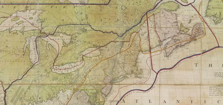
John Mitchell (1711-1768) was born in Virginia and educated at Edinburgh University in Scotland; he practiced as a physician back in Virginia before retiring to London in 1745. A botanist, Mitchell was soon adopted as an expert on exotic plants by the avid gardeners among Britain’s high society (Berkeley and Berkeley 1974). One of those gardeners was the earl of Halifax, president of the Board of Trade and Plantations, who also used his new colonial friend as an expert on the affairs of Virginia and of North America generally. By 1749, Halifax had recruited Mitchell to make a large and detailed map of the British and French colonies. At the time, the leading politicians in Britain were seeking a territorial compromise with the French in order to avoid further war. But Halifax used the final version of Mitchell’s map to persuade both his government colleagues and the British public, that such a compromise would be utterly disastrous. When published in London by Andrew Millar in March 1755, as A Map of the British and French Dominions in North America, Mitchell’s map quickly spawned a host of smaller, cheaper derivatives that widely publicized Halifax’s stringent interpretation of Britain’s colonial territories (Edney 2008).
Mitchell’s map is large: printed from eight sheets, it measures 136 cm (4'5") high by 195 cm (6'5") wide when assembled. It is known in a total of seven variants prepared over a twenty-year period. The last variant was published in 1775 by William Faden, who changed the title to A Map of the British Colonies in North America (Edney 2007). Close derivatives of the map were also published by Dutch, French, and Italian map publishers (Stephenson 1972).
The high regard in which Mitchell’s map was held is evident from the manner in which negotiators in 1782 used various impressions of different variants and derivatives of the map to define the boundaries of the fledging United States of America. The final boundaries were published in the Treaty of Paris, 1783. Yet the Treaty’s description of the U.S. boundary was ambiguous and the eastern portion of the US-Canadian boundary remained in dispute. Diplomats continually referred back to Mitchell’s map in order to resolve the treaty’s ambiguities, achieved in 1842 for the landward boundary and 1984 for the seaward boundary. Mitchell’s map was also cited as an authoritative source in many boundary disputes between U.S. states. The map’s legal and diplomatic use led Col. Lawrence Martin, when chief of the Library of Congress’s Geography and Map Division, to call Mitchell’s map “the most important map in American history” (Martin 1934).
During the Treaty of Paris negotiations, the British diplomat Sir Richard Oswald, annotated his impression of Mitchell’s map with a series of lines describing the different British and French claims to North American territory over the course of the eighteenth century; the (final) negotiated boundary he drew in a thin red line. Oswald later gave his annotated map to the king and it was later transferred with the rest of the king’s extensive map collection to the British Museum (now British Library). This particular map is accordingly known as wither “George III’s map” or “the red-line map.” The second name is, however, confusing: there are many impressions of Mitchell’s map that were annotated with red lines at various stages of the treaty negotiations and later as well (Edney 1997).
In 1997, the Osher Map Library and Smith Center for Cartographic Education received the gift of one of the other “red-line maps.” The map had been acquired at a Boston auction. This map comprises an impression of the final, 1775 variant of the Mitchell map, in original publisher’s color, to which were added, in 1898, copies of Oswald’s annotations from the George III map. The lines were added, according to a small explanation, by G. E. Hawkins, a draughtsman in the Intelligence Division of the War Office in London. It has been privately suggested that the annotations were made to recreate the George III map for use in the ongoing dispute over the US-Canadian boundary through the fish-rich Gulf of Maine.
Further Reading (online):
Edney, Matthew H. 1997. “The Mitchell Map: An Irony of Empire.” Osher Map Library, University of Southern Maine. https://oshermapsuat.wpengine.com/special-map-exhibits/mitchell-map.
Further Reading (print):
Berkeley, Edmund, and Dorothy Smith Berkeley. 1974. Dr. John Mitchell: The Man who Made the Map. Chapel Hill: University of North Carolina Press. [OML ref QK31 .M48 .B47]
Edney, Matthew H. 2007. “A Publishing History of John Mitchell’s 1755 Map of North America.” Cartographic Perspectives, no. 58: 4-27 and 71-75. [OML journals]
~~~. 2008. “John Mitchell’s Map of North America (1755): A Study of the Use and Publication of Official Maps in Eighteenth-Century Britain.” Imago Mundi 60, no. 1: 63-85. [OML journals]
Martin, Lawrence. 1934. “John Mitchell.” In Dictionary of American Biography, ed. Dumas Malone, 13:50-51. New York, Charles Scribner’s Sons.
Stephenson, Richard W. 1972. “Table for Identifying Variant Editions and Impressions of John Mitchell’s Map of the British and French Dominions in North America.” In A la Carte: Selected Papers on Maps and Atlases, ed. Walter W. Ristow, 109-13. Washington, D.C.: Library of Congress. [OML ref GA231 .A112 1972]
Matthew H. Edney
August 2012