

Collection: Morin Collection
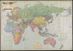
Name: Esso War Map II featuring The World Island, Fortress Europe: A second War Map edited, drafted, and printed by the makers of the well-known Esso Road Maps.
Barcode:
Image Number:
Alternative Title:
Physical Description:
Publisher:
Publishing Location:
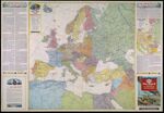
Notes: Marginal text titled: "The Geography of Global Warfare" and "Peace Conference Problems." Map shows railroads, roads, pipelines, steamship distances, and international boundaries as of March 11, 1938. Includes ancillary map, Boundary changes in Central Europe since 1938."
Date/Date Range Produced:
Date/Date Range Published:
Language:
Dimensions: 78 x 77 cm on sheet 86 x 122 cm
LC Call Number: G5670 1943 .G4 c.4
OCLC: 4358695
Accession Number: MOR-1943-38
Donor:
Subjects:
Permanent URL: