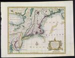
A New and Accurate Map of New Jersey, Pensilvania, New York and New England, with the adjacent Countries. Drawn from Surveys, assisted by the most approved Modern Maps & Charts, and Regulated by Astronomical Observations. By Eman. Bowen copy 2
Collection:
Smith Collection
Name: A New and Accurate Map of New Jersey, Pensilvania, New York and New England, with the adjacent Countries. Drawn from Surveys, assisted by the most approved Modern Maps & Charts, and Regulated by Astronomical Observations. By Eman. Bowen copy 2
Barcode: 1895
Image Number: 1895.0001
Creator: Bowen, Emanuel, 1693 or 1694-1767
From Atlas: Yes
Notes: Copy 2 of SM-1747-7; copy 1 is uncolored. From the author's "A Complete System of Geography." 1747. Note lower left: "No. 100. "
Atlas Reference: A Complete System of Geography, 1747
Subjects: Cartouches, Ornamental (Decorative arts)ConnecticutDelawareFlowersGreat Lakes (North America)MaineMarylandMassachusettsMiddle Atlantic StatesNew EnglandNew HampshireNew JerseyNew York (State)Nova Scotia (Canada)OntarioOntario, Lake (N.Y. and Ont.)PennsylvaniaplantsQuebec (Province)Rhode IslandVermont
Date/Date Range Produced: 1747
Date/Date Range Published: 1747
Language: English
Map Type: Geographical
Dimensions: 35 x 43 cm
Printing Process: Engraving
Printing Technique: Copper
Material Type: Paper
Brief Description: Map showing New Jersey, Pennsylvania, New York and New England.
Physical Description: 1 map: colored (hand-applied outline), illustrated
OCLC: 5402713
Accession Number: SM-1747-8
See Also: A New and Accurate Map of New Jersey, Pensilvania, New York and New England, with the adjacent Countries. Drawn from Surveys, assisted by the most approved Modern Maps & Charts, and Regulated by Astronomical Observations. By Eman. Bowen copy 1
Donor: Smith
Permanent URL:
https://oshermaps.org/map/1895.0001