

Collection: Osher Map Library Collection
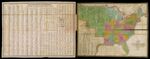
Name: Map of the United States Constructed from the Latest Authorities.
Barcode:
Image Number:
Creator:
Alternative Title:
Physical Description:
Publishing Location:
Notes: Accompanying page is titled "Traveler's Directory and Statistical View of the United States." Statistical table on map gives area, 1830 population, and capitals of states and territories, population of principal cities and towns, and total U.S. population. Colored by state and territory; upper and lower borders of United States in purple and orange, respectively. Traveler's directory lists steam boat and canal routes and principal roads, and their distances; length and breadth of states and territories, their population at different periods, increase of population from 1820 to 1830, and population per square mile; number of inhabitants by age for different races, handicaps, and for aliens; population of states, counties and principal towns.
Date/Date Range Produced:
Date/Date Range Published:
Language:
Dimensions: 42 x 55 cm and 43 x 56 cm respectively, folded to 13 x 8 cm
Printing Process:
Printing Technique:
Material Type:
LC Call Number: G3700 1834.W5
OCLC: 26164577
Accession Number: OML-1834-21
Donor:
Permanent URL: