

Collection: Osher Collection
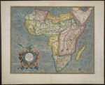
Name: Africa Ex magna orbis terrae descriptione Gerardi Mercatoris desumpta, Studio & industria G.M. Iunioris.
Barcode:
Image Number:
Creator:
From Atlas:
Publishing Location:
Notes: From: Mercator-Hondius-Janssonius atlas, 1633-38.
Atlas Reference:
Subjects:
Title Translation:
Alternative Title:
Brief Description:
Physical Description:
Publisher:
Date/Date Range Produced:
Date/Date Range Published:
Language:
Region Depicted:
Map Type:
Dimensions: 38 x 47 cm.
Printing Process:
Printing Technique:
Material Type:
Historical Context: Until the mid-nineteenth century, the African continent was an unknown entity to western cartographers. On maps from the Renaissance, such as this 1633 map by Gerardus Mercator, the continent?s outline is delineated fairly accurately but its interior is depicted according to conjecture and hearsay.The Nile river is shown with the two lakes and the Mountains of the Moon across southern Africa. Mercator shows Portuguese exploration up the Cuama (Zambezi) River into the interior of south central Africa in the region of Monomotapa or Benamataxa.
LC Call Number: G8200 1633 .M4
OCLC: 819749432
Accession Number: OS-1633-3
Donor:
Permanent URL: