

Collection: Story Collection
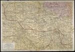
Name: Rand McNally War Map of the French Front Northern Section strategic map of the battle ground in northern France from St. Quentin to St. Mihiel, showing the farthest advance of the Germans in 1914 and the battle line in September, 1917
Barcode:
Image Number:
Publishing Location:
Date/Date Range Produced: 1918
Language:
Region Depicted:
Dimensions: 55 x 80 cm
Physical Description: 1 map: colored, illustrated
LC Call Number: G5831.S7 .R36 1918
Accession Number: ST-1918-20
Donor:
Subjects:
Permanent URL: