

Collection: Osher Map Library Collection
Name: Map depicting the final Allied offensive in Europe, July-November, 1918.
Barcode:
Image Number:
Publishing Location:
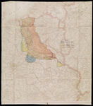
Notes: Depicts the final Allied drive of World War I known as the Hundred Days Offensive. The Germans were driven from France and behind the Hindenberg Line which resulted in the armistice agreement of November 11, 1918. Legend shows the Allied advance in phases separately colored. The yellow-shaded area at lower right to east of Hindenberg Line indicated the Battle of Saint Mihiel where the American Expeditionary Force under Pershing eliminated a German salient but failed to capture the fortified city of Metz.
Date/Date Range Produced:
Date/Date Range Published:
Language:
Dimensions: 89 x 77
LC Call Number: G5721.S65.M3 1918
OCLC: 936180509
Accession Number: OML-1918-2
Subjects:
Permanent URL: