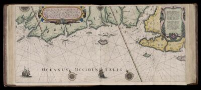
Caarte no. 5 || Chart number 5: True description of the sea coasts of Brittany and Poitou, between Ile-de-Sein and Island of Saint Martin de Re (Ile de Re).
Collection: Osher Collection
Name: Caarte no. 5 || Chart number 5: True description of the sea coasts of Brittany and Poitou, between Ile-de-Sein and Island of Saint Martin de Re (Ile de Re).
Barcode: 7356
Creator: Blaeu, Willem Janszoon, 1571-1638
Date Created: 1608
Date Published: 1608
Language: Dutch
Region Depicted: Brittany, FrancePoitou, France
Subjects: Brittany (France)Poitou (France)
Permenant URL: https://oshermaps.org/map/7356.0073