Research Fellowship Opportunities
The Osher Map Library and Smith Center for Cartographic Education at the University of Southern Maine offers fellowships to assist researchers, artists, and educators in accessing our rich and varied collections, which include nearly half a million cartographic items that are global in scope and date back to 1475.
New in 2025, we are pleased to offer annual visiting fellowships in honor of Dr. Harold L. Osher and Mrs. Peggy L. Osher. These short-term visiting fellowships offer fellows the opportunity to visit the library and spend time with the collections.
The Osher Map Library is a proud member of the New England Regional Fellowship Consortium (NERFC), a collaboration of 30 major cultural agencies in New England who award 25+ $5000 research fellowships annually. Fellowship awards are open to U.S. citizens and foreign nationals who hold the necessary U.S. government documents. Grants are designed to encourage projects that draw on the resources of several agencies. For more information on fellowship requirements and to apply for a fellowship (applications due February 1, 2026), please visit the NERFC application website at the Massachusetts Historical Society.
Short-Term Visiting Fellowships (New in 2025)
Dr. Harold L. Osher Visiting Research Fellowship
The Dr. Harold L. Osher Research Fellowships are intended to provide time for research, writing, and thinking about maps and mapping as they relate to advanced research in the humanities, social sciences, and related disciplines. Projects that explore underrepresented narratives in history are especially encouraged. Fellows spend a total of two weeks at the Osher Map Library, immersing themselves in the cartographic and reference collections. They are invited to be active participants in the intellectual life and community of the Osher Map Library and the University of Southern Maine during their stay, including giving a brown-bag lunch talk during their second week on site.
The Short-Term Research Fellowships are open to scholars at any stage of their career. Students must be ABD, and in the dissertation stage of their program, or in the equivalent stage of another terminal academic degree (e.g., MFA).
Applicants selected for the Dr. Harold L. Osher Research Fellowship will be awarded $2,500 for a two-week fellowship to take place on site at the Osher Map Library and Smith Center for Cartographic Education in Portland, Maine. The two weeks do not have to be consecutive but must both take place between December 2025 and December 2026 for the 2025-2026 award cycle.
Fellows receive half of the stipend ($1,250) upon scheduling their fellowship visit/s and the other half ($1,250) upon successful completion of the fellowship and submission of a required 250-500 word report.
HOW TO APPLY
Applicants must fill out the Application Form online.
Applications for the Dr. Harold L. Osher Visiting Research Fellowships are due by Monday, December 1, 2025 (11:59pm EST). Applicants must include how they plan to use the collections and the season(s) they intend to be on site. In addition to the online application form, graduate student applicants must submit one brief letter of recommendation (250-500 words) from an advisor/mentor.
Please note that at this time, unfortunately, we cannot sponsor visas for fellowships.
We will award two Osher Visiting Research Fellowships for the 2025-2026 cycle. All applicants will be notified of their status by January 1, 2026.
Depending on availability and timing of the visits, housing at the University of Southern Maine’s Gorham Campus (in our Visiting Artist House) may be available [at no additional cost to the fellow]. The Gorham Campus is 25 minutes from the Osher Map Library on the Portland Campus, and can be accessed by city bus (every 30 minutes) or by car.
Questions about the Harold L. Osher Research Fellowship program can be directed to Louis Miller, Assistant Director for Research and Fellowship Programs: louis.miller@maine.edu
Peggy L. Osher Visiting Artist Fellowship
Beginning in 2024-2025, the Osher Map Library has hosted a visiting artist for a short-term fellowship established in honor of Peggy L. Osher. These short-term fellowships/residencies at the Osher Map Library (typically two weeks) are designed to further the artist’s visual or performing art through the study of cartography.
Currently visiting artist fellowships are by invitation only, and are offered to artists actively engaged in work with maps and mapping (broadly conceived) as part of their practice. Fellows received a $2500 stipend and assistance with housing while in residence, and generally give a public lecture or workshop as part of their residency. Visual and performing artists interested in being a Peggy L. Osher Visiting Artist at the Osher Map Library should contact our Executive Director, Dr. Libby Bischof, who coordinates this program: elizabeth.bischof@maine.edu
2024-2025 Peggy L. Osher Visiting Artist: Billy Gerard Frank
(painting/film/multimedia)
2025-2026 Peggy L. Osher Visiting Artist: Adrienne Ottenberg (illustration/cartography/textiles)
Elizabeth Shurtleff and Helen McMillin, Highways and Byways of Girl Scouting, 1927.
Caroline Gerber, from Cousins Island, Maine, graduated from Yarmouth High School in June of 2025. She completed a research internship at the Osher Map Library and Smith Center for Cartographic Education during the summer of 2025, and is now a Freshman at Haverford College in Haverford, Pennsylvania. She plans to major in History.
Since the fall of my senior year of high school, I knew I wanted to spend my summer gaining valuable research experience prior to beginning my first year of college. It’s often difficult to find these kinds of internship opportunities before college, so I was absolutely thrilled to be able to work with Dr. Libby Bischof at the Osher Map Library this summer.
Libby, a historian and the Executive Director of the Osher Map Library, has been researching and planning various writing projects about 20th century female pictorial mapmakers for some time, but due to her busy schedule, she needed a hand in finding additional examples of these maps, creating a comprehensive list of the cartographers, and writing short biographies of these women. My internship researching American women pictorial mapmakers from the 1920s-1980s was a continuation of the work of Libby’s research assistant from last summer, Sophia Tuchinsky, who had given me a great starting place. She and Libby had created a spreadsheet with two tabs, one with several columns detailing where certain maps could be found, the titles, who made them, and what year they were published, and another with the alphabetized names of the cartographers and the space to write a short biography.
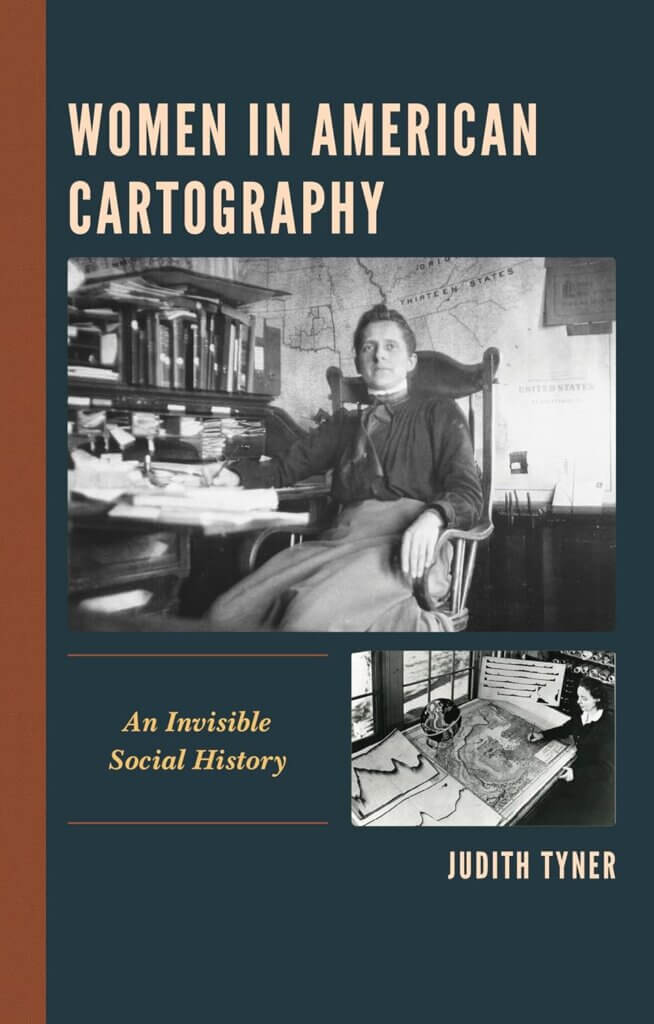
My first step in this project was to read up on pictorial maps. Libby checked out two books from the Osher Map Library for me: Stephen J. Hornsby’s Picturing America: The Golden Age of Pictorial Maps and Judith Tyner’s Women in American Cartography: An Invisible Social History. I thoroughly enjoyed these books as a student with an interest in history, but they also prepared me well for this internship by explaining the background of pictorial maps, including how these maps are defined and why so many women pursued them.
![]()
A pictorial map is a map with illustrations woven into it, usually to detail a particular story or the history of the location depicted. This style of cartography was more accessible to women because pictorial maps didn’t require as much cartographic accuracy as traditional maps, which usually required schooling and additional training, and, as such, was historically restricted to predominantly men. Many women artists and graphic designers also found pictorial mapmaking to be an accessible complement to their existing artistic practices. This was true of Elizabeth Shurtleff from Concord, New Hampshire, who studied at the school of the Museum of Fine Arts in Boston, and then produced a variety of illustrated pictorial maps of New England and beyond in the 1920s-1940s. Pictorial maps weren’t always produced on traditional media such as paper, either. Mary Ellen Crisp (1896-1974), for example, created patterns of maps to be embroidered. Her work was sold in department stores, allowing women who were skilled in domestic crafts to practice a form of cartography. Although only one of her map designs is easily accessible online, as part of David Rumsey’s collection in California, newspapers of the time include illustrations of some of her other embroidered designs, among them, maps of the Pacific and European theaters of World War II.
Finding and tracking down the locations of the actual pictorial maps made by women was relatively easy, albeit time-consuming. I was able to browse digital maps through several online library and map dealer collections, including the Osher Map Library, the Library of Congress Map Division, the David Rumsey Map Collection, Barry Lawrence Ruderman Antique Maps, Geographicus, and Curtis Wright Maps, to name a few. To ensure I wasn’t skipping over anything, I went through each individual map labeled or categorized as “pictorial” in these collections and then determined if the maps in question were created by a woman. Sometimes, I initially believed a map to have been created by a woman cartographer, but several names that are considered to be primarily feminine today were actually used for men in the 20th century, so I ran into a few dead ends.
Although the process of looking through thousands of individual pictorial maps across various online collections took a lot of time, almost two weeks, it yielded more than 150 new names to add to the list of women pictorial mapmakers. To date, we have identified 332 pictorial maps made by 188 different women between 1920-1980.
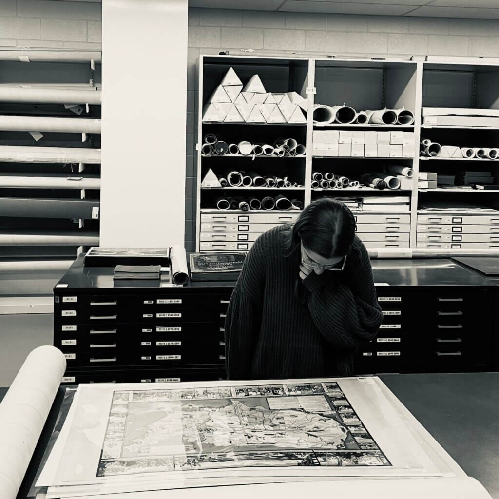
Caroline working in the Osher Map Library & Smith Center for Cartographic Education vault.
The much more difficult part of this project was the biographical research I conducted after I researched and recorded the names of the women cartographers and the titles of their maps. During the 20th century, it wasn’t uncommon to see a map produced by a Mrs. [Husband’s first and last name], such as “Mrs. Walter Henricks.” Most of the time, although it took extra work, I was able to discover the first and last name of the woman behind the map, separate from her husband. Mrs. Walter Henricks was actually named Namée Olivia Henricks (née Price) and lived a highly interesting life, contributing to beautiful pictorial maps. I was able to find the names of these women using websites such as Newspapers.com and Genealogy Bank, which provide digital archives of newspapers, some of which included announcements and articles about the publication and distribution of these pictorial maps, and occasionally additional biographical information about their creators. On these websites, I was able to search by full names and find any related newspaper articles mentioning the women I was researching. It was particularly helpful to come across wedding announcements and obituaries, as they often included important information about the people involved, such as their education and place of birth.
Other useful websites were FamilySearch and Find a Grave, which provide census records and other government documents to piece together and corroborate biographical information found in newspapers, helping me ensure that I was writing about the right person.
Overall, my internship was incredibly valuable, and confirmed that my passion in academia is history. I was fascinated by the lives of all these women, and their ability to create art and teaching materials during war, and during a period where so many of their rights were heavily restricted by society. These women proved that there were more opportunities for them than most people knew. For many of these women, cartography was a passion alongside their jobs as engineers, pilots, artists, and authors. I’m so grateful to have had this experience, and there’s still so much more to learn about these incredible women.
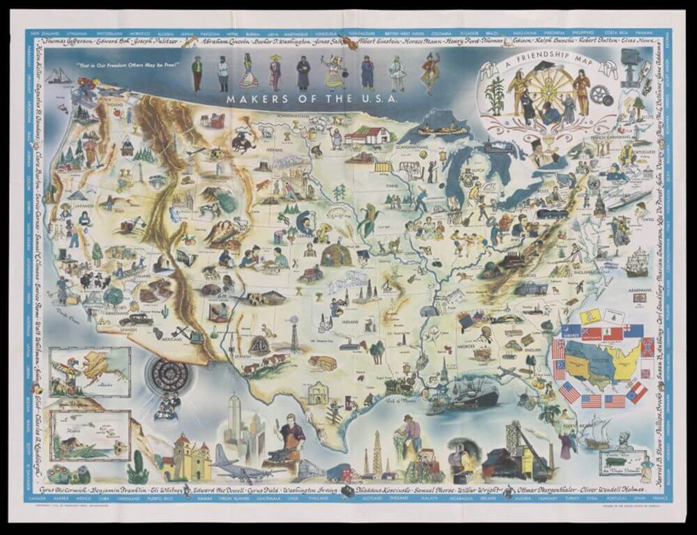
Louise E. Jefferson, Makers of the USA: A Friendship Map, 1957
Safford Automatic Draw Bar Co. Business Card [front], 1893
Garrett Jones is a senior History major at the University of Southern Maine; he interned at the Osher Map Library and Smith Center for Cartographic Education during the spring 2023 semester. His internship was supervised by Louie Miller, Cartographic Reference and Teaching Librarian. In the following post, he reflects on his experiences working with a collection of trade cards and advertisements that taught him a great deal about historical ephemera and social history.
Most of my time spent studying history at the University of Southern Maine has been focused on grand events, places, and people who have had a significant influence on the state of our present. From Revolutions in China to the Age of Imperialism, these events have left a tangible mark on the trajectory of all of our lives. The grandiose nature of these events, however, can almost make them feel disconnected from the more mundane nature of our daily lives. This is one of the big challenges of looking into the past; how do we actually place ourselves in the shoes of those who came before us? How can we view the world as they did? My time interning at the Osher Map Library and Smith Center for Cartographic Education (OML) during the spring 2023 semester helped reconcile these challenges for me personally by offering a direct glimpse into the daily lives of average people living in the past.
My internship at the OML was part of the USM History Department’s “Putting History to Work” internship program, and was focused on the cataloging and analysis of a collection of ephemeral advertising cards held by the map library. These cards consisted of trade cards, transportation tickets, stamps, business cards, and various other materials dating from the mid-1800s to the early-1900s. Over the course of the internship, I gathered relevant information for each individual card, such as a potential date range, place of origin, and some basic historical context surrounding the item with the aim to (hopefully) provide more accurate metadata for each item on the website.
This type of historical research was a fairly stark departure from the norm for me, as I shifted from researching grand historical events and narratives for my classwork (where I often have an abundance of readily available research material to analyze), to a series of relatively unknown or short-lived businesses and/or individuals which I have garnered a much smaller pool of information in regards to historical context. Most of the trade card and advertising items I analyzed were not initially created with the intention of being historically significant or preserved in any way (many of them were quite literally disposable or used as scrap paper). Indeed, it was the mundane lack of spectacle exhibited by each source that often piqued my interest. Many of these cards offered direct insights into the daily lives of ordinary people, helping me (and hopefully other students and researchers) gain a better understanding of what life was like in the past.
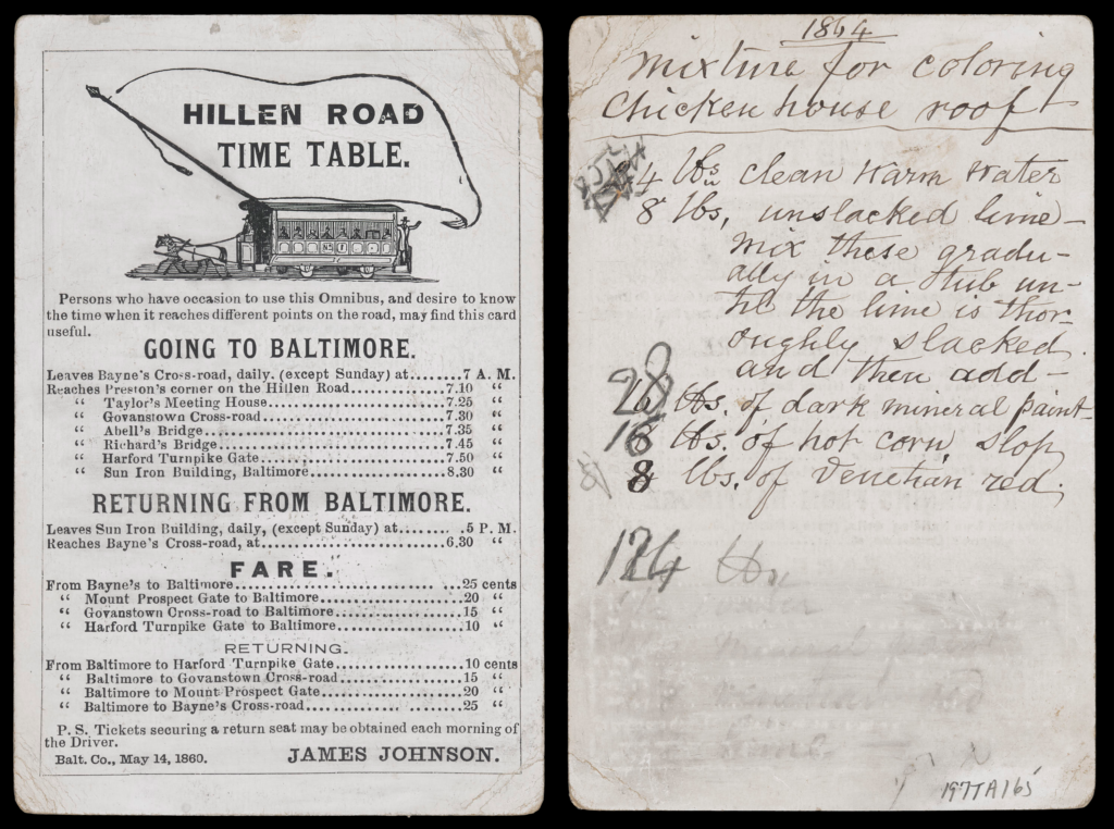
Some of the most interesting items I came across fascinated me not because of the literal trade-related information they conveyed, but rather, due to the clues as to how the cards were used by those who came to possess them. For instance, some of the items I viewed had been utilized as scrap paper for whatever notes their owner had deemed necessary at the time. Some examples of these were a business card dated to 1860 with a list of materials for a chicken coop written on the back in pencil, or a letter concerning housing renovations that was written on the back of a transportation company advertisement from around 1870. Items like this served a dual purpose of highlighting what types of businesses were commonly utilized by average people in this time period (especially related to transportation), as well as showing the direct, unfiltered perspective of the people who owned these ephemeral items via their individual notes. These personal notes significantly contributed towards an understanding of the physical conditions of the items as well as revelations about how people used such advertising materials beyond their initial intentions. In the same way that we might write on the back of an envelope or advertising postcard today, these nineteenth-century trade card owners used the valuable blank spaces for various notes and recipes.
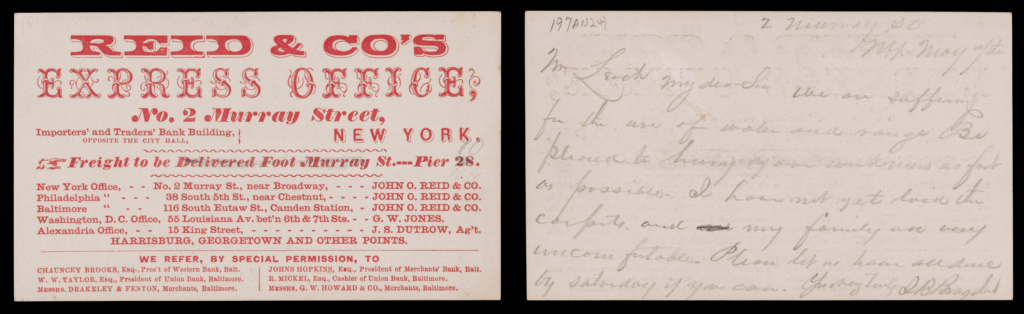
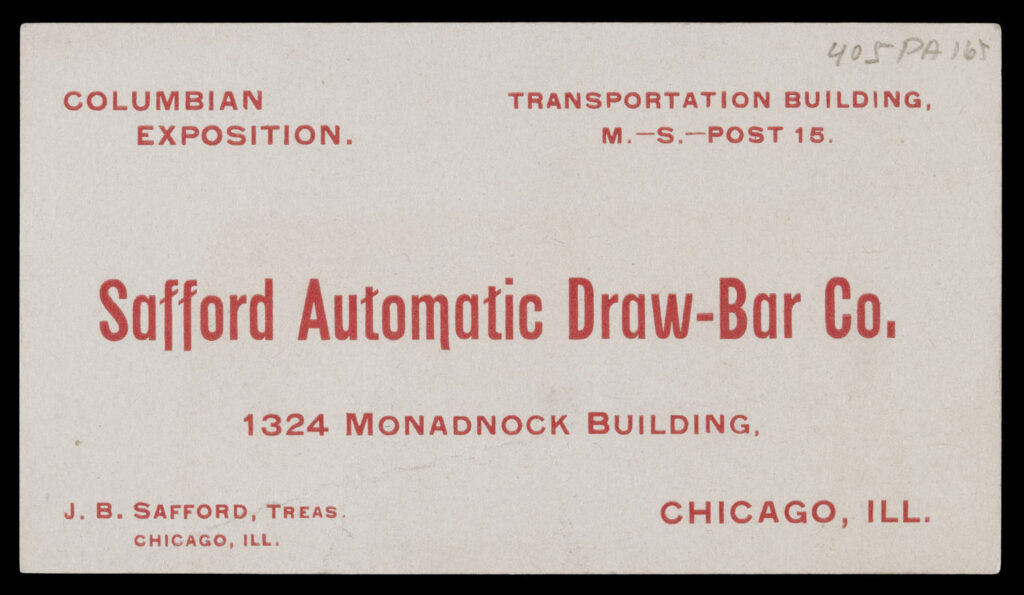
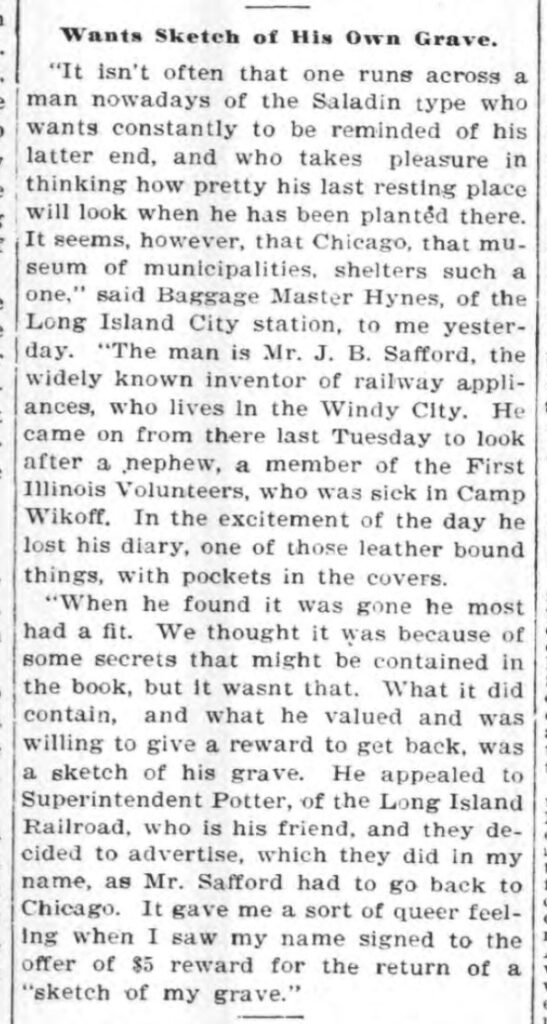
While some cards were more difficult to research than others, one of the most reliable ways I was able to find information on each item I analyzed was via newspaper articles. Even the most obscure individuals or businesses were likely mentioned in a local newspaper in some form, be it an advertisement, or a report on a building fire or lawsuit. If I was able to find information on an item in a newspaper, understanding how the person/business was portrayed in the paper offered an interesting look into how they fit into society at that time. While most were fairly standard, such as transportation companies offering discounts or steamboats advertising their routes, occasionally I would find a reference to an item I was analyzing in a bizarre excerpt from a local newspaper. One particularly unique example of this was when I was searching for information regarding a business card for Safford Automatic Draw Bar Co. On its surface, the automatic draw bar doesn’t appear to be the most enthralling subject matter; however, after researching the name of the company’s treasurer, J. B. Safford, I was able to find a newspaper article that helped to confirm the card was produced in the 1890s. What was interesting about this specific example was that the newspaper article in question was related to Safford’s lost diary that depicted a sketch of his gravesite. Apparently Safford was quite enamored with the concept of his appearance after his death, a concept that was seemingly quite weird even in 1898, as the paper mentioned, “it isn’t often that one runs across a man nowadays… who takes pleasure in thinking how pretty his last resting place will look when he has been planted there.” While the item itself may seem mundane upon first glance, further research often provided fascinating insight into the drama, gossip, and day to day activities of these business and card owners.
Overall, I learned a great deal from my internship at the Osher Map Library. Beyond the new research skills I was able to hone, the internship taught me to broaden my horizons regarding what primary sources I choose to engage with when trying to gain an understanding of the past. It is easy for us to get swept up in the high visibility, grand historical events of the past, but it should be known that it is equally important to approach an understanding of the past from the perspectives of average individuals and the mundane details of their everyday lives.
EXHIBIT NAVIGATION
Stately Cartography: Fifty Maps of Fifty States
1. State Maps of the Early Republic
2. Mitchell Maps
3. Asher & Adams Maps
4. Rand McNally Maps
5. National Geographic Maps
6. National Highways Association Maps
7. Persuasive Maps, Atlas Maps, and Unique Treasures
8. Federal Writers Project and American Guide Maps
9. State Trading Cards
10. State Postcards
11. Pictorial State Maps
12. Hand Drawn Maps
During the late-eighteenth century, some educators advocated teaching geography by having their students copy printed maps by hand, another form of the rote education popular in the United States. While the practice of student-drawn maps began in Europe, Emma Willard and other American educators promoted the technique in schools and academies throughout the United States. The maps of New York [#50] and Rhode Island [#49] are examples of hand-drawn manuscript maps created by American students during the early-nineteenth century.
Occasionally, the identity of the printed map being used by these student mapmakers as a reference is obvious. For example, the maker of the Rhode Island map was clearly copying “State of Rhode Island” from one of the many editions of Mathew Carey’s General Atlas. The student even faithfully copied the printed map’s title cartouche with its credit to Caleb and Harding Harris. The printed map copied by the student mapmaker of the New York map is more difficult to identify. The student’s inclusion of Sullivan County and Schenectady County, both created in 1809, indicates that the printed reference map was produced during or after 1809. Likewise, the lack of Putnam County, which was incorporated in 1812, indicates that the printed reference map was produced prior to 1813. This does not mean, however, that the manuscript map of New York was produced between 1809 and 1812; it is highly likely that the student could have copied the printed map years after it was published.
Rhode Island
49. The State of Rhode Island, c.1820
Smith Collection
https://oshermaps.org/map/4489

More About Rhode Island
Statehood: 1790
Fun Fact: The Rhode Island Red Chicken Breed has it’s own statue dedicated to it in Little Compton, Rhode Island.
New York
50. State of New York, c.1820
Donated by Maine Historical Society
https://oshermaps.org/map/45810

More About New York
Statehood: 1788
Fun Fact: Pearl Street in New York City used to be paved with oyster shells.
EXHIBIT NAVIGATION
Stately Cartography: Fifty Maps of Fifty States
1. State Maps of the Early Republic
2. Mitchell Maps
3. Asher & Adams Maps
4. Rand McNally Maps
5. National Geographic Maps
6. National Highways Association Maps
7. Persuasive Maps, Atlas Maps, and Unique Treasures
8. Federal Writers Project and American Guide Maps
9. State Trading Cards
10. State Postcards
11. Pictorial State Maps
12. Hand Drawn Maps
Arizona
This map was produced as a supplement to Reg Manning’s 1938 book, Cartoon Guide of Arizona. Reg Manning, a well-known syndicated cartoonist from Phoenix, eventually became known as “The Cactus Cartoonist,” because when signing his cartoons, he often included a small smiling cactus alongside his name. Manning enjoyed a long and respected career, winning the 1951 Pulitzer Prize for Editorial Cartooning for his cartoon, “Hats,” a commentary on the Korean War.
Although this map does not include Manning’s cactus signature, it has no shortage of cacti; much of the map’s imagery depicts the flora and fauna of the state, as well as natural features, historic landmarks and events. The map, made to look like it was drawn on birch bark, also includes images of traditional Hopi, Navajo, and Apache crafts and practices. In addition to historical facts and anecdotes, Manning included messages that urged his readers not to be tempted by the state’s beautiful highways to speed on through, but rather warned that they would “miss too much that you should see if you drive too fast!”
43. Reg Manning, Cartoon Map of Arizona from Reg Manning’s Cartoon Guide of Arizona, 1938
Osher Map Library Collection
https://oshermaps.org/map/3461

More About Arizona
Statehood: 1912
Fun Fact: The Grand Canyon in Arizona is bigger than the entire state of Rhode Island.
Oregon
Ruth Taylor, the author of this map of Oregon, became known for her colorful pictorial maps, which she called “cartographs,” over her long career as a cartoonist. This map is from the atlas, Our USA: A Gay Geography, which features 56 of Ruth’s maps set in the United States and its territories. Frank Taylor, Ruth’s brother, wrote the text that accompanies each map. The maps in the atlas are vibrantly colored and filled with images of landmarks, landscapes, and people, many of which are active and emotive.
While this atlas was well-received at the time of its publication in the mid-1930s, twenty-first century audiences cannot help but notice the problematic racist stereotypes and colonialist imagery present throughout the maps in this atlas, particularly in the maps of the deep south and southwest. Although Taylor’s map of Oregon is one of the least offensive maps in the atlas, modern viewers will note that the people included on the map are overwhelmingly white and involved in some form of economic or recreational activity, while the three Native Americans featured are depicted more as passive scenery, each marking the location of a reservation. As scholar Dori Griffin explains, Taylor’s maps “reveal not only the aesthetic and conceptual preferences of their maker but also the cultural biases of their middle-class, white American audience.”
44. Ruth Taylor, Oregon from Our USA: A Gay Geography, 1935
Gibb Collection
https://oshermaps.org/map/40385.0091

More About Oregon
Statehood: 1859
Fun Fact: Oregon’s Crater Lake is the deepest lake in the United States.
Virginia
Charles William Smith (1893-1987), a native of Virginia, was a painter, printmaker and art professor best known for his linoleum block and woodcut prints. He also published a series of illustrated books in the 1920s and 1930s that depicted episodes and prominent places in Virginia’s history.
In Smith’s pictorial map of Virginia, he chose to emphasize the state’s historical attributes rather than its geographical features. The map depicts Virginia’s early history—from early British contact in 1607 by Christopher Newport and John Smith—up through the Civil War. Included around the border of the map are illustrations of 34 historic homes, churches, buildings, and monuments, including Thomas Jefferson’s Monticello, George Washington’s Mount Vernon, the Raleigh Tavern at Williamsburg, as well as presidential birthplaces. The map inset shows Old Richmond and the present day capital.
While Virginia was the scene of many important battles of the Civil War from 1861 to 1865, the map does not feature any of these battlefields. Rather, the map serves as a subtle testament to the mythology of the “Lost Cause,” which emerged in the Reconstruction era following the war. If you look carefully throughout the map, the heavily colonial historical narrative is interspersed with elements of the Confederacy, including General Lee’s birthplace, the site where he was buried, as well as building sketches of the Confederate Museum in Richmond, and the last “White House of the Confederacy,” in Danville. These subtle nods to Virginia’s Confederate past were, no doubt, intentional inclusions, especially during the era of Jim Crow and segregation. The map is highly decorative, in pastel tones, with a beaming sun shining down on Virginia. Smith’s design highlights only selective historical episodes, depicted in a positive light, while ignoring some of the more challenging aspects of Virginia’s history. Even pictorial maps can be political.
45. Charles William Smith, A Historical Map of Virginia, 1930
Smith Collection
https://oshermaps.org/map/2268

More About Virginia
Statehood: 1788
Fun Fact: An annual pony swim is held in Virginia.
Ohio
Following the success of the Columbian Exposition in 1893, Chicago hosted its second world’s fair, A Century of Progress International Exposition, from 1933 to 1934. One of the many buildings on the fairgrounds, the Hall of States, represented approximately 23 states in 1933 and 14 states in 1934. As the program of A Century of Progress explains, the state exhibits “observed a common theme– the portrayal of their undeveloped natural resources and their historical, recreational, and scenic features.”
This map was featured on the cover of Ohio’s pamphlet accompanying their exhibit. Keeping with the theme of the states’ expositions, the map features many of Ohio’s natural resources and history. As the map itself says, instead of a “wordy booklet or other literature,” the Ohio Commission offered copies of this map to visitors to keep as a “remembrance memento” of their visit to Ohio’s exhibit and a reminder to visit.
46. Ohio Commision to A Century of Progress International Exposition, Being a Cartograph of Ohio, 1934
Osher Map Library Collection
https://oshermaps.org/map/45556

More About Ohio
Statehood: 1803
Fun Fact: Seven past presidents were from Ohio.
Connecticut
Produced in 1935 by the Aetna Casualty & Surety Company to celebrate Connecticut’s “Tercentenary,” this map depicts contemporary roads and highways alongside 33 illustrations of historical events and landmarks, each described in detail in the key along the right and left margins. Many of the historical events and landmarks featured on the map are in some way related to the Revolutionary War, while others depict significant locations and events in preceding colonial wars. The fraught relationship between the Native American tribes of Connecticut and European colonists is largely ignored in the illustrations on this map, with the exception of one nod towards the atrocities committed by the colonists. To this end, the paragraph about the Great Swamp Fight, numbered “11” on the map, explains how one hundred and eighty Pequots were enslaved by Captain John Mason at the end of the Pequot War. The reverse side of the folding map features historical sketches, descriptions and photographs of landmarks, and an invitation from Governor Wilbur Cross to “Be in Connecticut in 1935.”
John Held, Jr., a well-known illustrator and cartoonist, designed the commemorative map. Although Held never graduated high school or had formal art training, he experienced success as an illustrator starting at a young age. At age nine, he sold his first drawing to a local newspaper, and by age 15, he had sold a cartoon to Life magazine. His distinctive, stylized cartoons, like the ones featured on the map, went on to be published in many other prominent magazines, including The New Yorker, Vanity Fair, and Harper’s Bazaar. During World War I, Held served as an artist and cartographer for the U.S. Naval Intelligence in Central America. Despite his wild success in the 1920s, Held suffered a mental breakdown after losing the majority of his assets during the Great Depression. His career had still not entirely recovered by the time this map was made.
47. John Held, Map of Connecticut, 1935
Morin Collection
https://oshermaps.org/map/45947

More About Connecticut
Statehood: 1788
Fun Fact: Connecticut is home to the nation’s oldest newspaper in continuous publication.
Maine
The pictorial map, Maine: Its Recreation and History, was made by M. C. Linscott and issued by the Maine State Highway Commission in 1935. Linscott often included artistic renderings of people and places to add depth and meaning to the maps he created, as we can see in this colorful map summarizing life in the Pine Tree State.
Linscott thoughtfully decorated the state with wildlife, town buildings, historic sites, and even mermaids! Look closely, and you might find a building you recognize from your hometown. To the right, the map is signed by Louis Brann, the governor of Maine at the time, along with the statement: “Life begins at the gateway of Maine.” This map was aimed at increasing the number of tourists who motored to Maine in the summer months, highlighting the natural resources and historic attractions that would entice visitors. Just as the map is framed by recreational activities, historic homes, and famous Maine residents, so has Maine life been shaped by the connections we make with one another and nature.
M. C. Linscott’s legacy is continued by his grandson, who now owns Linscott Maps. Today, the company makes custom maps that include artistic and historic details similar to those on this endearing 1935 map of Maine.
48. M.C. Linscott, Maine: It’s Recreation and History, 1935
Osher Collection
https://oshermaps.org/map/3978

More About Maine
Statehood: 1820
Fun Fact: The inventers of the Stanley Steamer, a steam-powered automobile invented in 1897, were born in Kingfield, Maine.
EXHIBIT NAVIGATION
Stately Cartography: Fifty Maps of Fifty States
1. State Maps of the Early Republic
2. Mitchell Maps
3. Asher & Adams Maps
4. Rand McNally Maps
5. National Geographic Maps
6. National Highways Association Maps
7. Persuasive Maps, Atlas Maps, and Unique Treasures
8. Federal Writers Project and American Guide Maps
9. State Trading Cards
10. State Postcards
11. Pictorial State Maps
12. Hand Drawn Maps
While the “Golden Age” of postcards in the United States is frequently identified as spanning from 1905 to 1915, it is important to note that Americans frequently bought and mailed postcards throughout the twentieth century, especially when traveling and on vacation. The three state map postcards on display here were all created in the middle decades of the twentieth century.
The latest of the three, “Greetings from Maryland” [#42], was produced by Boston’s Tichnor Brothers firm sometime in the 1960s (as indicated by the 1960 census figure on the reverse side). Similar to the popular pictorial maps of the 1930s and 1940s, the postcard features the locations of Maryland’s major cities and is crowded with images of locally produced foods and goods.
The postcard of Utah [#40] also shows the locations of the state’s principal cities, looking strangely disconnected as no roads or highways are depicted on the map. The postcard border features ten images of Utah landmarks, including the famous Great Mormon Tabernacle Organ in Salt Lake City, which was finished in 1948. Because the postcard’s publisher, E.C. Kropp Co. was only in business until 1956, this card was produced in the late 1940s or early 1950s.
“Oklahoma: The Sooner State” [#41] is the only one of the three postcards to include roads on its featured map, which depicts the principal routes through Oklahoma before the construction of Interstate 35. The map also shows the major cities and significant landmarks of the state, including the Grand River Dam, completed in 1940. Around the edges of the map are some images, including one of a bison, Oklahoma’s state animal, and some oil rigs, fitting since Tulsa was considered the “Oil Capital of the World” at the time this postcard was produced in the 1940s or 1950s.
Utah
40. E.C. Kropp Co., Utah, c.1950
Osher Map Library Collection
https://oshermaps.org/map/52069

More About Utah
Statehood: 1896
Fun Fact: Utah has an official state cooking pot, the Dutch Oven.
Oklahoma
41. Baxtone Publishing Co., Oklahoma: The Sooner State, c.1950
Osher Map Library Collection
https://oshermaps.org/map/52067

More About Oklahoma
Statehood: 1907
Fun Fact: The world’s first parking meter was installed in Oklahoma City.
Maryland
42. Tichnor Bros., Greetings from Maryland, c.1960
Osher Map Library Collection
https://oshermaps.org/map/52072

More About Maryland
Statehood: 1788
Fun Fact: Jousting is the offical state sport of Maryland.
EXHIBIT NAVIGATION
Stately Cartography: Fifty Maps of Fifty States
1. State Maps of the Early Republic
2. Mitchell Maps
3. Asher & Adams Maps
4. Rand McNally Maps
5. National Geographic Maps
6. National Highways Association Maps
7. Persuasive Maps, Atlas Maps, and Unique Treasures
8. Federal Writers Project and American Guide Maps
9. State Trading Cards
10. State Postcards
11. Pictorial State Maps
12. Hand Drawn Maps
Collecting advertising or “trade cards” became a popular hobby in the Victorian era, following the introduction and success of cigarette cards, which initially featured portraits of actresses and athletes and were used to stiffen the paper packages of cigarettes. Other companies soon followed suit with their own signature decorative trade cards, including the Arbuckle Brothers Coffee Company. The Arbuckle brothers founded their company in Pennsylvania after the Civil War, and innovated the industry by selling roasted coffee in one-pound packages. Their coffee was extremely popular in the western region of the country.
Arbuckle’s began issuing trade cards in collectible sets or series in the 1880s, after they moved their operation to Brooklyn, New York. One of the most popular series of trade cards produced by Arbuckle’s Coffee was a set of 50 cards, featuring maps of 40 states, nine territories (including Alaska), and the District of Columbia. In addition to a map, each card also includes the state or territory’s population, the area in square miles, and a representational landscape scene depicting commerce. For example, the North Dakota card [#37] shows scenes of sowing and reaping in a wheat field, and the Idaho card [#39] depicts an active salt well. Other cards feature scenes celebrating the wildlife of a state or territory. South Dakota’s card [#38] shows a vast herd of mule deer, and New Mexico’s card [#36] shows a hunting scene with a black bear, the official state animal. More than a century after they were produced, these richly illustrated, colorful cards remain highly collectible.
New Mexico
36. Arbuckle Bros. Coffee Co., New Mexico, 1889
Osher Map Library Collection
https://oshermaps.org/map/50427

More About New Mexico
Statehood: 1912
Fun Fact: New Mexico host’s the world’s championship for shovel racing.
North Dakota
37. Arbuckle Bros. Coffee Co., North Dakota, 1889
Osher Map Library Collection
https://oshermaps.org/map/50423

More About North Dakota
Statehood: 1889
Fun Fact: Bismarck, North Dakota holds the Guinness World Record for the most snow angels made simultaneously in one place.
South Dakota
38. Arbuckle Bros. Coffee Co., South Dakota, 1889
Osher Map Library Collection
https://oshermaps.org/map/50424

More About South Dakota
Statehood: 1889
Fun Fact: South Dakota hosts an annual Mashed Potato Wrestling event.
Idaho
39. Arbuckle Bros. Coffee Co., Idaho, 1889
Osher Map Library Collection
https://oshermaps.org/map/52074

More About Idaho
Statehood: 1890
Fun Fact: Idaho is home to the continent’s deepest river gorge, Hell’s Gorge, which is deeper than the Grand Canyon.
EXHIBIT NAVIGATION
Stately Cartography: Fifty Maps of Fifty States
1. State Maps of the Early Republic
2. Mitchell Maps
3. Asher & Adams Maps
4. Rand McNally Maps
5. National Geographic Maps
6. National Highways Association Maps
7. Persuasive Maps, Atlas Maps, and Unique Treasures
8. Federal Writers Project and American Guide Maps
9. State Trading Cards
10. State Postcards
11. Pictorial State Maps
12. Hand Drawn Maps
The American Guide Series was one of the most popular publications of the Federal Writers’ Project, a depression era program of the Works Progress Administration (WPA) employing over 10,000 writers, researchers, historians, and others. With a book devoted to each of the then 48 states, a typical book in the series featured photographs and essays about the resources, people, history, and economy of the individual state. The American Guide Series books also included travel routes and maps, often tucked into a pocket in the back of each book. The research and production for each individual guide often involved cooperative efforts between the state and federal governments, as well as municipal organizations. Like the Farm Security Administration photographs from the same era, these guides introduced America to many Americans who had never traveled outside of their states or regions.
Understandably, the state maps produced in the American Guide Series focused heavily on the major roadways. Some, like the map of Kansas [#31], highlight helpful locations for tourists, such as state parks and good spots for hunting, boating, and fishing. Similarly, on the back of the map of Delaware [#32] is a separate Delaware Recreation Map, showing locations for fishing, camping, boating, and golfing and complete with a list of fresh water fishing sights. Many of the maps, including those of Minnesota [#33] and Indiana [#34], mark points of interest with numbers that correspond to a legend on the margins of the map.
Kansas
31. Federal Writer’s Project, Kansas from Kansas: A Guide to the Sunflower State, 1939
Auletta Collection
https://oshermaps.org/map/49778

More About Kansas
Statehood: 1861
Fun Fact: Kansas is home to the world’s largest ball of twine.
Delaware
32. Federal Writer’s Project, Delaware from Delaware: A Guide to the First State, 1938
Auletta Collection
https://oshermaps.org/map/40691

More About Delaware
Statehood: 1787
Fun Fact: Delaware was the first state to ratify the Constitution.
Minnesota
33. Federal Writer’s Project, Minnesota from Minnesota: A State Guide, 1938
Auletta Collection
https://oshermaps.org/map/40771

More About Minnesota
Statehood: 1858
Fun Fact: Minnesota is home to the nation’s largest shopping mall.
Indiana
34. Federal Writer’s Project, Indiana from Indiana: A Guide to the Hoosier State, 1945
Auletta Collection
https://oshermaps.org/map/40742

More About Indiana
Statehood: 1816
Fun Fact: John Chapman, better known as Johnny Appleseed, is bured in Fort Wayne, Indiana.
EXHIBIT NAVIGATION
Stately Cartography: Fifty Maps of Fifty States
1. State Maps of the Early Republic
2. Mitchell Maps
3. Asher & Adams Maps
4. Rand McNally Maps
5. National Geographic Maps
6. National Highways Association Maps
7. Persuasive Maps, Atlas Maps, and Unique Treasures
8. Federal Writers Project and American Guide Maps
9. State Trading Cards
10. State Postcards
11. Pictorial State Maps
12. Hand Drawn Maps
Nevada
George Clason is perhaps most well-known for his essays on economics and financial independence, as well as his 1926 book, The Richest Man in Babylon. After serving as a Civil Engineer in the Spanish-American War, Clason moved to Denver, Colorado, and found employment as a draughtsman for local patent attorneys, mostly involved in the mining industry. Clason began producing his own maps for commercial sale in 1902, and formed the Clason Map Company in 1904. Clason’s business grew quickly, and by 1910 he had shifted from maps of Colorado to maps of western states beyond Colorado, as well as city maps of western metropolitan areas. Over the next decade and a half, Clason expanded the size and range of his company exponentially.
Clason was an early innovator in highway maps and quickly became known for his company’s road maps, touring atlases, and green guides. These pocket-sized guides consisted of a booklet containing information on the state or city and one or more large maps attached to the inside cover. The Clason Map Company produced the nation’s earliest road atlases, including the first road atlas of the United States and Canada, Clason’s Touring Atlas of the United States, which sold over a million copies. A financially-minded man, George Clason used his maps, atlases, and guides to promote migration to the West, as well as energy development. Many of Clason’s maps show oil, gas, and coal prospects, and he also published maps and brochures promoting recreation and tourism in an effort to draw visitors and residents to the region. The Clason Map Company was hit hard by the economic crash of 1931, and declared bankruptcy the following year.
24. George Samuel Clason, Sketch Map of Nevada, 1906
Naden Collection
https://oshermaps.org/map/41799

More About Nevada
Statehood: 1864
Fun Fact: Jeans as we know them today were invented in Nevada.
North Carolina
Using a culmination of surveys completed by the United States Coast Guard and Geodetic Survey, and the United States Army, among others, W.C. Kerr created this 1882 map of North Carolina. Color-coded by county, the map depicts towns, railroads, waterways, and swamplands. On the bottom, a list of towns with 500 people or more are listed, along with notes that include: latitude/longitude, elevation, population by race, etc. The map is dedicated to the then-Governor of North Carolina, Thomas J. Jarvis.
The bottom of this map has been stamped with information regarding immigration and land sales, calling into question the origins and original usage of this map. The map was published “Under the Authority of the State Board of Agriculture” and could have been used for distribution at Agricultural Fairs. These popular fairs were a way for farmers to show off new technologies and to provide entertainment for the masses. They were also a way for farmers to come together and learn about the world. The map could have contributed to a particular exhibit on immigration, or the south in general, as a way to show the typically isolated farmers what was developing around the United States. The stamp on this map points those with questions to Boston, a hub for these fairs.
25. W.C. Kerr, Map of North Carolina, 1882
Story Collection
https://oshermaps.org/map/4793

More About North Carolina
Statehood: 1789
Fun Fact: The world’s first flight in a aircraft took place in North Carolina.
Illinois
Samuel Augustus Mitchell started his career as a school teacher in the early- nineteenth century. Frustrated with the poor quality and inaccuracy of geographical resources available to teachers, he began publishing his own maps and geography textbooks.
Mitchell’s map of Illinois is attached to the inside cover of the book, Illinois in 1837. This book, published by John Grigg of Philadelphia, explains many of the advantages of moving out west. However, Mr. Grigg had a vested interest in the purchase of lands in Illinois. Circa 1825, the government announced it was going to give Revolutionary War veterans acreage to farm in the new land of Illinois, or it was to be sold by the government at $2 an acre. John Grigg purchased over 10,000 acres of land and, in many cases, he sold this land to settlers, farmers or migrants, for $3-$5 per acre. This publication, rife with westward expansion propaganda, would have had a personal interest to Grigg.
One section of this book, entitled “Suggestions to Emigrants,” provides information about how to reach the west by different transportation methods: steamboat, train, or stage. It also provides instructions for farming and building a home. As the author noted, “Any young man, with industrious habits, can begin here without a dollar, and in a very few years become a substantial farmer.” (70)
26. S. Augustus Mitchell and H.L. Ellsworth, Mitchell’s Map of Illinois from Illinois in 1837, 1837
Osher Collection
https://oshermaps.org/map/36842

More About Illinois
Statehood: 1818
Fun Fact: The world’s first ferris wheel was built in Chicago, Illinois.
South Carolina
This map of South Carolina comes from the 1796 atlas, The American Atlas, published by John Reid, and was designed to accompany William Winterbotham’s An Historical, Geographical, Commercial, and Philosophical View of the United States. The atlas has long been a popular format among map lovers because it assembles a variety of related maps and provides a convenient way to retain and preserve maps in a home library. Following the Revolution there was an urge to carve out the shape of America, separate from the British precedents. Most state governments began to organize state surveys, mapping out the new nation. The private sphere of map-making in the newly formed country was small to start, but grew quickly with the introduction of the first atlas of the United States, by Matthew Carey of Philadelphia (1794). After this initial atlas, book publishers added atlases to their lines and were soon very successful.
The second atlas to be engraved and published in the United States, and the first to feature a plan of the city of Washington, was published by John Reid in 1796. The American Atlas was designed to accompany William Winterbotham’s An Historical, Geographical, Commercial, and Philosophical View of the United States. Winterbotham’s work, published in London, was originally accompanied by An American Atlas, a series of nine maps of sections of America by John Russell. Reid copied nine of Russell’s maps and included sixteen additional maps. Reid was perhaps inspired by Matthew Carey, who had had remarkable success.
Prior to the introduction of Lithography in the U.S. (1827) and wax engraving (1841), printing and publishing maps and atlases was time intensive and expensive. These two new methods of printing allowed publishers to print a higher number of maps at a lower cost, making them affordable to many. Unfortunately, while the quantity of maps increased, there was a decline in quality.
27. John Reid, South Carolina from The American Atlas, 1796
Osher Collection
https://oshermaps.org/map/3542

More About South Carolina
Statehood: 1788
Fun Fact: South Carolina’s Charleston Museum was founded in 1773, and is regarded as “America’s First Museum.”
Washington
This map of Washington state was published in 1893 in The Matthews-Northrup Adequate Travel-Atlas of the United States. Published just four years after Washington’s statehood, the map depicts—as the title suggests—all railroads, cities, towns, and principal villages in the state. In addition, it also shows various waterways, mountain ranges, and Native American reservations, all designed to aid an increasing amount of westward travelers at the close of the nineteenth-century.
The Matthews-Northrup Company (also called Matthews-Northrup Works and later J. N. Matthews Co.) was known for squeezing as much information as possible onto each page of their atlases, thus creating a set of comprehensive and incredibly useful maps for travelers. Weighing only 12 ounces, the Matthews-Northrup Company achieved their goal of creating an imminently practical guide rife with minute and informative details, all while still able to be “shoved into a coat pocket.”
28. Matthews-Northrup Company, The Matthews-Northrup Adequate Travel Map of Washington from The Matthews-Northrup Adequate Travel-Atlas of the United States, 1893
Osher Collection
https://oshermaps.org/map/8037.0235

More About Washington
Statehood: 1889
Fun Fact: Washington’s Mt. Mitchell once got over 14 inches of rain in one day.
West Virginia
Appleton’s Atlas of the United States is comprised of general maps of the United States and territories, and a county map of each of the states, together with descriptive text outlining the history, geography, and political and educational organizations of the states, with the latest statistics of their resources and industries. The map of West Virginia on display here is from the 1885 edition.
D. Appleton & Company was founded by Daniel Appleton. As a merchant, Appleton frequently imported goods from abroad and began importing English books with his merchandise. In 1830 Daniel Appleton, along with his two sons, began publishing and printing material on a wide variety of subjects. D. Appleton & Company was particularly well known for printing the works of contemporary scientists at moderate prices. Daniel passed away in 1849 leaving the company to his sons. In 1869 they began to produce Appleton’s Journal, which later became known as Appleton’s Magazine.
29. D. Appleton & Co., West Virginia from Appleton’s Atlas of the United States, 1885
Osher Collection
https://oshermaps.org/map/7951

More About West Virginia
Statehood: 1863
Fun Fact: West Virginia is home to the second oldest river in the world.
Wyoming
This map is an example of persuasive cartographic design. Maps have been consumer goods for hundreds of years but it is only since the late-1800s that maps promoting other goods really came about. Promotional cartography is most often geared towards tourists, as travel is geographically focused and travelers rely heavily on geographic information. Promotional maps were first used to spur the development of railroad tourism. As local governments were largely responsible for road maintenance and improvement, and many rural communities did not have the money to do so, it could be dangerous to travel between towns and cities and road maps were necessary to show the safest routes and roads. By the early 1910s many large companies had a vested interest in consumers traveling, typically closer to them and their businesses, and sponsored the improvement of long motorways, often cross-country. The first federal road aid acts were passed in 1916 and 1921, helping to make routes more easily navigable and convenient.
Since most oil companies offered the same product, they attempted to stand apart with great service and free travel advice. The cost to the oil distributor decreased with the entrance of companies like Rand-McNally and Gallup. Every spare inch of the maps were filled with advertisements and graphics to promote the oil companies. These maps or atlases not only provided consumers with the routes, but also recommended hotels and provided information on the states and national parks. The Gallup Map Company is still in business today.
30. Gallup Map and Supply Co., Gallup’s Comprehensive Road Map of Wyoming from Highway Atlas of the United States and Canada , 1931
Yensen Collection
https://oshermaps.org/map/13847

More About Wyoming
Statehood: 1890
Fun Fact: In Wyoming, it is illegal to leave a fence gate open.
New Jersey
This engraved copper plate of the state of New Jersey was created around 1780 by Evert Bancker, Jr. His primary purpose was depicting partition lines that sectioned the state, as well as showing the borders between New Jersey and his home state of New York. The accompanying printed engraving shows us these lines distinctly, thanks to the detail of Bancker’s copper plate.
During the seventeenth and eighteenth centuries, many maps were engraved on copper plates because of the precise images that could be produced. Creators of these maps intricately engraved the copper by hand, using a sharp pointed steel tool called a “burin.” This process accounts for the impressive and minute details on Bancker’s map of New Jersey, such as the Revolutionary Era skyline of Philadelphia.
When copper plates were used to print maps, the image printed was always reversed from the engraving on the copper. So, the creators of the maps had to reverse the image as they engraved it. On the map of New Jersey, we see backwards “3’s” along the left and right sides of the map, as if the engraver mistakenly forgot to carve them in reverse.
35. Evert Bancker, The State of New Jersey, c.1780
Osher Collection
https://oshermaps.org/map/43566

More About New Jersey
Statehood: 1787
Fun Fact: Thomas Edison’s first lab was located in New Jersey.
EXHIBIT NAVIGATION
Stately Cartography: Fifty Maps of Fifty States
1. State Maps of the Early Republic
2. Mitchell Maps
3. Asher & Adams Maps
4. Rand McNally Maps
5. National Geographic Maps
6. National Highways Association Maps
7. Persuasive Maps, Atlas Maps, and Unique Treasures
8. Federal Writers Project and American Guide Maps
9. State Trading Cards
10. State Postcards
11. Pictorial State Maps
12. Hand Drawn Maps
These maps of New Hampshire [#20], Alabama [#21], Colorado [#22], and Arkansas [#23] were made during the 1910s, a time of energetic automobile development. 1914 marks the year that Henry Ford perfected his assembly line production, and within two years, the the yearly number of automobiles sold topped half a million. Understandably, as more automobiles were distributed, the demand for better roads increased. One of these voices was the National Highways Association, established by Charles Henry Davis in 1911 with the slogan “Goods Road Everywhere.” Davis stated “to have Good Roads everywhere throughout the United States will mean more to this nation than any other development since the Declaration of Independence.”
One of the main achievements of the National Highways Association is the amount of literature they put out, which included over 500 maps. The draughtsmen of the maps worked extensively with State highway officials to determine the best routes of the proposed national highways. The National Highways Association argued for national highways built by the Federal government as opposed to State or local governments, a controversial argument at the time. According to the National Highways Association, a national highway would lead to a variety of benefits—”social, moral, commercial, industrial, material, education, and personal”—and ultimately “bind the States together in a common brotherhood, and thus perpetuate and preserve the Union.”
While highway development was much slower than Davis and the National Highways Association hoped, eventually the benefits of a national highway system became apparent. As Thomas MacDonald, commissioner of the Bureau of Public Roads from 1939 to 1953, wrote, “We were not a wealthy nation when we began improving our highways… but the roads themselves helped us to create a new wealth, in business and industry and land values… So it was not our wealth that made our highways possible. Rather it was our highways that made our wealth possible.”
New Hampshire
20. National Highways Association, National Highways Map of the State of New Hampshire, 1914
French Collection
https://oshermaps.org/map/43177

More About New Hampshire
Statehood: 1788
Fun Fact: Months before his famous ride in Massachusetts, Paul Revere rode to New Hampshire to raise an alarm about redcoats coming to sieze gunpowder.
Alabama
21. National Highways Association, National Highways Map of the State of Alabama, 1915
French Collection
https://oshermaps.org/map/43175

More About Alabama
Statehood: 1819
Fun Fact: The only all-water mail route in the United States exists in Magnolia Springs, Alabama.
Colorado
22. National Highways Association, National Highways Map of the State of Colorado, 1919
French Collection
https://oshermaps.org/map/43179

More About Colorado
Statehood: 1876
Fun Fact: The tallest sand dunes in North America are located in Great Sand Dunes National Park in Colorado.
Arkansas
23. National Highways Association, National Highways Map of the State of Arkansas, 1919
French Collection
https://oshermaps.org/map/43173

More About Arkansas
Statehood: 1836
Fun Fact: The largest diamond unearthed in the United States was in Arkansas.
EXHIBIT NAVIGATION
Stately Cartography: Fifty Maps of Fifty States
1. State Maps of the Early Republic
2. Mitchell Maps
3. Asher & Adams Maps
4. Rand McNally Maps
5. National Geographic Maps
6. National Highways Association Maps
7. Persuasive Maps, Atlas Maps, and Unique Treasures
8. Federal Writers Project and American Guide Maps
9. State Trading Cards
10. State Postcards
11. Pictorial State Maps
12. Hand Drawn Maps